Sent-Pierro (Étalie)h I;·p Nearped T110iont60Rr 9Aa23.n 8Ee5Cc i
| Cél articllo est ècrit en arpetan supradialèctâl / ORB lârge. |
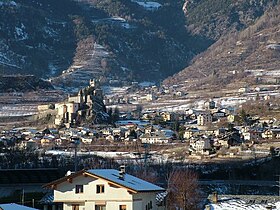
| Sent-Pierro | ||||||||||||||
 Hèraldica |
||||||||||||||
 |
||||||||||||||
| Noms ètrangiérs | ||||||||||||||
|---|---|---|---|---|---|---|---|---|---|---|---|---|---|---|
| Nom francês | Saint-Pierre | |||||||||||||
| Administracion | ||||||||||||||
| Payis | ||||||||||||||
| Règ·ion | ||||||||||||||
| Province | ||||||||||||||
| Sendeco | Paolo Lavy 2010-2015 | |||||||||||||
| Code postâl | 11010 | |||||||||||||
| Code ISTAT | 007063 | |||||||||||||
| Code cadastrâl | H674 | |||||||||||||
| Prèfixo tèl. | 0165 | |||||||||||||
| Dèmografia | ||||||||||||||
| Populacion | 3 162 hab. | |||||||||||||
| Densitât | 122 hab./km2 | |||||||||||||
| G·eografia | ||||||||||||||
| Cordonês | 45° 43′ 00″ B 7° 14′ 00″ L / 45.71667, 7.2333345° 43′ 00″ Bise 7° 14′ 00″ Levant / 45.71667, 7.23333 | |||||||||||||
| Supèrficie | 2 600 ha = 26 km2 | |||||||||||||
| Localisacion | ||||||||||||||
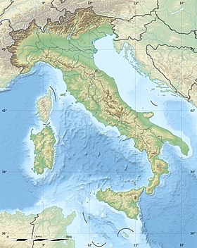
| G·eolocalisacion sur la mapa : Vâl d’Aoûta
G·eolocalisacion sur la mapa : Étalia
G·eolocalisacion sur la mapa : Étalia
| ||||||||||||||
| Lims | ||||||||||||||
| Seto Vouèbe | http://www.comune.saint-pierre.ao.it/ | |||||||||||||
| changiér |
||||||||||||||


Sent-Pierro, tot-pariér Sent-Pierre, est una comena du Vâl d’Aoûta.